


News
IN THE NEWS
Inverloch locals losing beach to erosion support disputed rock bag wall fix - ABC News
Will Gold Coast's beaches be restored by Easter? Radio National Breakfast
Novel Australian project examines if renewable energy machines can protect coastlines
Tourist Beach to close due to Coastal erosion (Yahoo)
ABC Melbourne Conversation Hour report on Victoria's Eroding Coastline 10 Sep 2024
Beach Monitoring Project

Next Beach Monitoring Date TBC

SE side of Griffiths Island
Left
11 February 2023
Right
6 June 2026

Quick Summary Table
Gallery

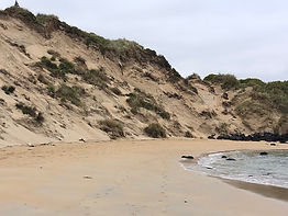
Our collection of photographs reflect the diversity of views of our esturary and coastline.
Year 6 School Science project
_JPG.jpg)
Once or twice a term students from local primary schools join PFCG and help measure sand levels at Pea Soup and South Beach. Drones cannot be used to measure sand levels on these beaches so a laser is used to make transverse and longitudinal measurements.
The council uses the data to inform its coastal protection and rehabilitation work.
St Patrick's Primary School and Port Fairy Consolidated School are currently involved with this project
_JPG.jpg)


JOIN THE TEAM
PFCG is always on the lookout for enthusiastic new recruits to join our beach monitoring sessions. If you are interested contact us to find out more.